Wednesday 4 August 2010

Haresfield, Standish, Moreton Valence; 23 July 2010

Today Is nearly an out and back route, finishing near to the start.


I left the office in Hucclecote and headed for Upton St Leonards.  Often at this point, I would head uphill towards Painswick but not today.  Today I head out through Matson and on to Brookthorpe, cross Stroud Road and into the village of Haresfield.  About 10Km into the ride already, time to find a village church, fortunately Haresfield has one of them  but it is a little bit hidden.  
Hidden, in fact up track that has a large steel gate and a (small) sign declaring private road in quite big print and access to church and old vicarage only in smaller print.  I venture through the gate.  This is all indeed shown as a road and public path on my OS map.  However, it is stunningly beautiful and, in my submission, unwelcoming at the same time.  So to my grumble of the day.  If the Church of England is interested in attracting new members, then surely this is the sort of thing they really must stop doing.  I appreciate they want to keep the grounds in good condition, which is done really quite successfully, but at the expense of putting people off.  The old guard, I'm sure are comforted and possibly made to feel quite sanctimonious by these restrictions.  However, they won't be around forever.  The 'Keep off the grass', 'Don't let your dog foul', 'Private' and other signs, the gravel drive that appears to be a private drive all conspire to put you off.  I felt like a trespasser as I entered through the gate and had to walk my bike, the gravel was far too thick to ride on.  I suggest that if it is necessary to keep these buildings purely as historical buildings, then hand them over to (for example) English Heritage and ship the congregation off to a nearby church.  There are plenty about and I'm willing to bet none of the congregation walk.  If it is intended to be a place of worship, then open it up and employ a good caretaker and groundskeeper.
Rant over, the Church of St Peter is a stunning church dating back to 12th century and an incredibly impressive 15th century range of buildings that comprise the old vicarage and would, 500 years ago, no doubt have isolated the church even then as being above the common man.  (Sorry I said rant over).  The church comprises of comprises nave, chancel of two compartments, west tower and spire, and north and south porches.  Some of the original 12th century fabric still exists including decoration and ornamentation over the north doorway and north walls.  The church was rebuilt in the 14th century when the west tower with a spire, gargoyles, and a staircase turret on the north, and the porches were added.  In the mid 18th century, the church was re-roofed and repairs carried out on the tower and spire.  Interior restoration later in the 18th century led to accusations that some ancient  details.  Something must have gone wrong at some point as it was described in 1841 as 'unwholesome, uncomfortable, and squalid'.  This led to a thorough restoration in the next year.
Curiously, right next to the church on the East side, there is moated site, known as The Mount. A square moat encloses an island measuring approximately 50m by 48m. The motte at the centre now only stands 1.5m high but was previously recorded as 10ft high. The moat is 10 to 16m wide and 3-4m deep. The moat is believed to be the site of the manor house of Haresfield which was still standing in 1680.  From my position, it was difficult to see anything on the mount.  I would have to do that by foot along one of the many converging footpaths.

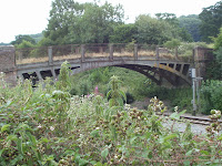
A kilometre or so south(ish) from Haresfield is a railway bridge that now looks rather sorry for itself, I have linked to this on the location link that you should see at the bottom of the blog.  A look at the OS map suggests that this would at one time been a road link towards Stonehouse and the area east of the railway line.  I'm no expert on railways or bridges, but I guess that this is industrial revolution type era so quite a change in the politics of the area.  The bridge now just leads to a farm.


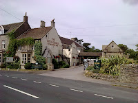
Carrying on, heading east, next stop is Standish.  On the approach, you get an excellent view of the grade II listed village hall and 14th century church of St Nicholas.  Despite the church you can now see having been built in the 14th century, it is believed to have replaced a wooden Saxon church.  The church is grade I listed and restored in the 1860s.  Legend has it that the body of Edward II was brought to Standish church in 1327 on its way to being interred at Gloucester Cathedral.  A much more reliable historical reference can be found inside the church.  At the end of the 16th century, Sir Henry Winston was Lord of the Manor of Standish; his memorial in the church bears a 20th century sign:

"This monument to Sir Henry Winston was restored to commemorate the marriage in 1618 of his daughter Sarah to John Churchill from which union descended Sir Winston Churchill K.G. O.M. C.H. M.P. 1874-1965 Prime Minister 1940-1945 . 1951-1955"
This Sarah Winston's grandson became the first Great Duke of Marlborough, ancestor of Sir Winston.
In the grounds of the church are, probably, 14th century vicarage buildings that are now used as community and parish offices (I believe).  The openness and use of this church strikes a stark contrast to that at Haresfield whilst losing absolutely nothing of its majesty.


To the west of the church is, as the map says, a gateway.  This is, in fact, a very impressive ruined gatehouse leading to Standish court and to a house built by Abbot of Gloucester, probably dating from the 14th century. Sadly, beyond this point is private land.


The village of Standish is in fact a little bit of a misnomer.  It is a small scattered parish of less than 100 households spread out along 2 miles of the main road between Stonehouse and Gloucester.  It has no shop, no post office, no school and no pub.  So you're unlikely to meet my brother there.


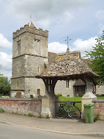
And so I start to head north back towards Gloucester.  Stopping off at Moreton Valence and the church of St Stephen.  The nave and chancel are early 12th century, the tower 15th century followed by the south aisle.  A bit of a varied management as  no vicarage was ever established in Moreton Valence.  The parish changed hands between Standish and Moreton and Whaddon before the Bishop of Gloucester joined it with Whitminster in 1961.  Most of the curacy lived in other parishes.  One notable exception being the 1570 curate John Day.  He obviously didn't ingratiate himself to the parishoners having been described as 'to be 'no peacemaker, of late a weaver, ... a drunkard and an unruly man who put his pigs into the churchyard.  Perhaps the church needs more people like that?
Alongside the church is another moat.  A bit of a theme here I feel.  Again, not expected but another photo opportunity.  This is thought to be the site of a fortified manor house, the hall built by William de Valence in 1253. It was documented again in 1324 but was probably in a state of disrepair by 1372. No evidence has been found to support the traditon that this is the site of a castle.

From  here, the journey back to Barnwood could be a straight ride up the A38 but I have time on my hands.  So, without further stops, I cross over the canal and take a trip round Epney and Longney, again some beautiful, quiet well surfaced roads, a pleasure to ride on.  Dropping back over the canal at Hardwicke, through Quedgeley and onto the new(ish) bypass.  The canal was rerouted for the bypass, although they still bridged it, but this is a long reasonably straight pan flat road where one can be quite satisfied with a reasonable turn of pace for relatively little effort.  From here, I drop onto the inner ring road, onto Estcourt Road befor heading north into Longlevens and picking up the cycle path into Barnwood.


Total distance - 46 KM
Average Speed - 29.5 KM/h
Weather - about 23C, Dry, wind from NW, about 5 KM/h

Monday 19 July 2010

Lechampton, Shurdington; 15 July 2010

Today's route is a fairly flat circular route that just skirts Cheltenham.  I do revisit some previous locations but all in the interests of finding some other places that the Ordnance survey map has promised.
To start, I left Hucclecote and headed roughly North over Churchdown Hill, dropping in towards the village and out into Badgeworth.  Now, I shall tell you at this point that I decided to keep my heart rate quite low, ideally below 165 bpm, this meant that I spent more time than normal in the small chainring and spinning at a reliable 90-100 rpm.  For all that, overall speed didn't seem to suffer so quite happy with that.  The only thing that conspired against me was the wind.  Strong enough to make quite a difference yet never a proper tailwind.
From Badgeworth Lane, I turned left to Cold Pool Lane and through Up Hatherley and onto Shurdington Road. Crossing Shurdington Road, I head towards Leckhampton on the delightfully named Kidnappers Lane.  This takes us out right by St Peter's church, Leckhampton.  On this occasion, however, it's not the church I am after.  Rather Ordnance Survey indicates a moat on the other side of the road.  You can't ride right up to the moat but it is on a footpath so it's a hike of 100 metres or so.  The moat is dry but a quick jump down into reveals some squelching so I guess it isn't always as dry.  Maybe I'll go back when we have had some more wet weather and let you know.  Anyway, the enclosure is only small and nineteenth century excavations turned up stones that probably formed the foundations of a bridge from approximately 10th century and a paved road from the church so it is possible that it was related to an earlier (Saxon) place of worship on the same site.

Back on the road and off to Shurdington.  I've never really taken any notice of Shurdington before, save that it  is between Gloucester and Cheltenham and I have ridden or driven past it a million times.  Shurdington has existed as a village since Norman times and has a rather lovely church that bares testimony to it's age.  It also has a street naming convention in common with many other villages.  Imagine the medieval town planners meeting:
"Right, we need to give these new-fangled roads a name so people will know where they are going."
"That's not neccessary, no-one can read"
"No but let's show willing.  Shall we start with the lane with the church on it?"
"Oooh, I know, there's learning done there.  So how about school lane?"
"Good, I like it.  Now, how about the lane with a school on it?"
"Bugger, can't think of anything for that one."

St Paul's, Shurdington church is, in fact, a magnificent although very small Norman building with a very impressive 109 foot tall spire that has been repeatedly struck by lightning and repaired, there are a number of dates inscribed in the spire from where renovation work was carried out.  One (probably apocryphal) tale regarding the spire is that the builder took his own life, so distraught was he that he was unable to match the spire at nearby St Peter's.
The church has, as you would expect, been much changed and added to in its lifetime.  One benefactor, immortalised in an inscription on the sundial on the South wall, is the Gwinnet family, a family of wealthy local merchants who acquired Bageworth manager during the reign of Elizabeth I.  One of the ancestors of this family was one Button Gwinnet who was one of three representatives of Georgia who signed the US Decleration of Independence.

Behind the church are the school rooms, probably mid-eighteenth century dame or Common Day school, that were used for there original purpose until 1981 when they joined up with Badgeworth.  The buildings are now in use for the communtiy.


 Leaving the village and crossing the main A46 (Shurdington Road) I cross into Farm Lane.  I wonder what might have been here when the planners got together?  I strongly expect that the Cheese Rollers pub or at least the buildings behind used to form the farm, but can't be sure.  This lane is just a short diversion loop off the main road more or less just doing a lap of the pub grounds.  It is also home to a jolly uninspiring grey building that is Shurdington Chapel.


Back onto the A46 and towardsBrockworth and I have time to spare so, where better to sit back and take in the view for half an hour so?  Back to where the blog all began, to Witcombe Roman Villa.  In fact, the road here is the steepest climb of the day.  Deceptive but quite a climb none the less and giving fantastic views over Witcombe.


Total distance - 26 KM

Average Speed - 27 KM/h
Weather - about 23C, Dry, wind from SW, about 30 KM/h

Friday 2 July 2010

Birdlip, Brimpsfield; 2nd July 2010

Today's journey could easily have been about 2 Km long and of no real interest and not worth blogging.  But not if you go this way.


From Hucclecote to Birdlip there are two reasonably obvious ways to get to Birdlip.  One way is my normal climb past Prinknash Abbey before turning left, almost back on yourself, through Cranham Wood.  A long climb about 12Km in total.  The other way is up through Witcombe and likely to shred your lungs and cause your leg muscles to spontaneously explode.  Fearing the mess, I choose the longer way.  Take a look at the elevation profile.  My chosen route is approximately Km 1-12, the alternative is the way I came down and is 17.5 to 21 Km.  You get the picture.


First destination is the village of Birdlip and, approaching from Buckholt Road, the first real sign of the village is the Royal George.  A curious mix of a place.  A proper locals pub also welcoming for passing trade including walkers and cyclists, although it is right on the Cotswold Way so I guess there is a fair amount of rambling trade.  Also, a popular venue for weddings and a corporate type conference centre.  The existing pub was built around a (probably) 17th century coaching inn.


Moving on into the village is one of the smallest churches ever.  The Parish church of St Mary.  Originally Birdlip was served by a mission church built in 1897.  A tin shed type of building although immaculately equipped inside.  The church sadly burnt down in 1954.  The village was devastated and, undeterred, the vicar, the Revd. H.D. Atkinson spearheaded a campaign to raise the money and build a new church out of stone (not a three little pigs story, I promise).  The site of the church moved its current location and building started in 1957 by which time the vicar had sadly died.  His widow laid the foundation stone on 25th May 1957.  This stone is in the porch  of the building.


Leaving Birdlip, I head for Brimpsfield.  Before I do though, it is worth noting that in common with many areas consisting of smaller villages, there is a Benefice connecting the churches.   These separate parishes are Birdlip, Brimpsfield, Syde, Daglingworth, The Duntisbournes, Winstone, Miserden and Edgeworth.  I shall have to find the others another time.

The road to Brimpsfield is an experience.  There is a mini valley between the two villages.  The roaddrops down at a precarious angle before climbing again at a similar angle.  Arriving in Brimpsfield, I can see no sign of the church.  There is a house called 'The old Post Office'-you see, village post office closures are nothing new, a memorial cross and a load of chickens wandering around in the road.  However, no sign of a church.  Now, I am sure there is a church here somewhere so I ask the local chap loading his car.  He kindly points me in the right direction.  Turning into the road I was directed into, the kindly chap runs behind shouting to tell me I have missed the turning.  Bemused, I stop.  Friendly bloke is a little way behind me so it would be a bit rude to hold a shouty conversation.  There is, however, an older woman stood at the bus stop.  I'm reasonably sure she wasn't there 3 seconds earlier.  Lady tells me to be careful as there is a bus coming that is more or less the width of the road.  Thoroughly terrified at the thought of being turned to jam by the bus, I ask her if she can direct me to the church.  I am then privileged to be given a potted history of the village and how it grew around the church which in turn was built on the site of a much older, probably iron age motte castle.  Maybe she remembers all this first hand?  Given the amount of Iron age settlements in this area this sounds reasonably likely.  Anyhow, the woman points me down a 'road' that apparently leads across the old site to the church.  It's just a dirt track.  You really do need to know the church is there.  Even when you are proper close, you can't see the church.
However, the effort is worth it.  St. Michael's church, built from local Cotswold stone, boasts a Norman nave and chancel, further additions made through to the 14th century with the battlemented tower built circa 1500.  The church was restored in the 1880s.  The churchyard is a large sprawling area with tree lined and arched pathways.  There are a number of tombs and sarcophagi back to early 18th century.  All that being said, the church is a beautiful building and set in glorious peaceful surroundings.


I return to Birdlip on the same roller coaster and descended through Witcombe, the previously described hill back into Gloucester.


Total distance - 26 KM

Average Speed - 25 KM/h
Weather - about 24C, Dry and sunny, wind from SW, about 10 KM/h

Sunday 27 June 2010

Crickley Hill; 25 June 2010

Today's ride could have been a very dull 3 Km very flat from Brockworth to Hucclecote then a reasonably staid 8Km home.  But that's not the way I operate.  That first 3 Km became a 20Km hilly ride.  You can see the route  here.


Allow me to set the scene.  This afternoon was Vic's sports day at school in which she came 3rd in her races with her house group winning overall so congratulations to the yellow team.  I was a spectator (and ran (poorly) in the dad's race).  Afterwards, I was to meet Tina at work for a joint bimble home.  However, I now have an hour or two spare so best not let this go to waste, this calls for a trip up to Crickley Hill - a one stop ride today.


Leaving Brockworth, I could easily ride straight up Shurdington Road but today is about avoiding the obvious so a lap of Bentham is in order before eventually heading up Shurdington Road and turning onto Leckhampton Lane.  Past St Peter's church and uphill through Leckhampton.  So far so good.  Almost a carbon copy (without stops) of this ride here.  Towards the top of Leckhampton Hill though, I turn off to Crickley Hill Country Park.  If the climb thus far hasn't killed you, the little access road into the country park probably will.  First, cross a wide spaced cattle grid, then up the 45 degree (or so it feels) slope and you will realise why the cattle grid as you ride through herds of cows before cresting where you are greeted with another cattle grid (sorry fillings) and one of the most stunning views across Gloucester.  If you live anywhere near Gloucestershire and haven't been to Crickley Hill, shame on you.  Apart from offering stunning views and good walking countryside, the country park is a site of nature conservation, geological & archaeological interest.  There is a well equipped visitor centre on site manned by keen and knowledgeable staff.  The site has been occupied since approx 3500 BC and excavations from 1969 onwards exposed an Iron age hill fort, wooden posts have been used to identify the location of the buildings and the embankment that would have circled the site is still very much in evidence.  I shan't write any more about this, rather here are a couple of pictures that don't do justice.
You don't have to go further than the car park to get this view.
 Looking across the valley with Chosen Hill in the middle distance
 You may just be able to make out the markers in the ground that show the location of post holes from the iron age settlement.  At the rear of the picture is the defensive bank.  Far left would have been the entrance.
 This is my bike parked at the entrance where the gatehouse would have been.

Before we leave the country park, I must regale you with a quick story from the recent history.  One winter when my daughter, Victoria, was very young and just started talking, I took her to Crickley Hill as it had been snowing and I hoped there may be proper snow at the top of the hill.  I was a little disappointed to find nothing more than a reasonably hard frost.  Undeterred, Vic ran around the site of the settlement like a loony in her spotty wellies.  Coincidentally, my brother and his wife were also on the hill so I had stopped and was chatting to them.  Excited to see Uncle Daz and Aunty Shaz Vic came running back in that slightly awkward way 18 month old kids do and put her arms up to me and said 'Daddy, carry, knackered'.  I really don't know where kids get these things from sometimes.

Leaving the country park, that access road is as scary going down as it is hard work going up.  Right at the end to the Air Balloon pub and in to Birdlip.  It's all downhill now through Witcombe, into Brockworth and on to Barnwood where a meet Tina from work and we take a jolly civilised bimble home.

Total distance - 34 KM
Average Speed - 25 KM/h
Weather - about 26C, Dry and sunny, wind from SW, about 10 KM/h


Saturday 26 June 2010

Painswick, Pitchcombe, Whaddon; 23 June 2010

From today's route and profile you will notice that I have eschewed the simple flat routes in favour of some of the local hills again.  And a delightful sunny day for doing so.  Also, after my last ride, I strongly suspect you are suffering from 'Russ visits church' withdrawal symptoms.


Leaving Brockworth, I head for Painswick where I have circumvented several times and promised a visit sometime.   That time is now.  My preferred route as I am sure you are aware is straight up the A46, Painswick Road, passing Prinknash Abbey, through Cranham and past the beacon.  Once you pass Painswick Beacon, there is a very satisfying downhill into Painswick until you realise that at some point in the near future you will have to go back up.  Right at the start of Painswick Road, some 4 Km ago there were signs warning that the road into Painswick was closed.  I took the risk that the footpaths wouldn't be and I would be able to use them.  The gamble paid off.  


No surprises but arriving at Painswick we stop at St Mary's Church.  The earliest parts of the current church, the North aisle and inner chancel date from late 14th century although they replace a Saxon church that was built on the site.  The main fabric of the church was modified and added to right up to mid 18th century, the 
nave and tower about 1480, the spire added in about 1632, and the south aisle was built about 1741.  On the 10th June 1883 (I missed the 127th anniversary by a fortnight), the church was struck by lightning, the tower suffering worst and masonry took out large chunks of the roof.  The masonry was faithfully replaced in its original position.  The church is also famous for the grounds.  Many of the tombstones being elaborately decorated by local stonemasons and date prior to 1860, when the churchyard was closed for burials. Subsequent interments took place in the cemetery on the slopes leading up to Painswick Beacon.  The churchyard, criss-crossed by footpaths, is also home to a number of well trimmed yew trees.  Folklore holds that the churchyard will never have more than 99 yew trees and that should a 100th grow the Devil would pull it out.  All the trees now have numbered plaques on them.  I shall leave it to you to do the count yourself although one record shows 103, another shows 100.  For it's small size, Painswick has a long and interesting history.  If you want to read more, you could do much worse than starting here.


Coming out of Painswick, I pass through Pitchcombe.  Let's split the name place up.  Pitch - old English word for slope of a hill.  Combe, again old English, this time for the uppermost part of a valley.  No great surprises then, this is uphill.  I decided to take the steep road through the village.  Not much purpose to that, there isn't much to see except for a cyclist struggling up a hill with his lungs in his throat.
The parish church of St John, Pitchcombe, is a little further North along the main road.  Pitchcombe, in common with Painswick, is a member of the Beacon's benefice which comprises of:
Painswick (just up above)
Cranham
Sheepscombe
Edge (just a bit further down)
Pitchcombe (right here)
Harescombe (passed by, not stopped there yet)
Brookthorpe 


Curiously, Cranham Pitchcombe, Edge and Harescombe all have parish churches called St John the Baptist.  I don't know if there is good reason for this.


The current church at Pitchcombe is early 19th century although stands on the site of a former Church known as the Pitchcombe Cradle which was built in 1376. The present church bell is thought to date from somewhere between 1350 and 1380 so possibly installed at the older church.


Carrying on towards Edge, I pass the Edgemoor Inn.  A quite unassuming nineteenth century purpose built inn, although it is, I believe a free house and last time I ate and drank there it was fine fare.  That aside, you won't find many pubs anywhere with such fantastic views as these offer over the Stroud valleys.


Next stop isn't very far away.  As previously mentioned the church at Edge is the church of St John the Baptist.  There doesn't seem to be so much information available for this church so I shall subtly sidestep my usual history lesson in favour of a bit of a moan.  This a beautiful church with a well kept graveyard and fabulous views.  However, it was like walking in to your houseproud aunt's living room.  There is an outer door that wouldn't look out of place at a correctional institution.  I may be wrong but I find it hard to believe that there is a big crime problem here.  There is also a sign banning anything other than fresh flowers and imploring you to ensure they are removed when they go over so that the grounds are kept looking nice.  I walked my bike around the gravelled path and I'm fairly sure someone will be tutting the tyre grooves soon.  It really didn't feel welcoming.  If the church is serious about encouraging people, this sort of thing must be addressed.  Still, here are some pictures 'cos despite all that, it is pretty.


Leaving Edge, I travel downhill.  This is a very fast 3Km or so, nice and twisty with some quite severe drops to add a bit of interest and would probably be a quicker route if the surface of the road wasn't quite so teeth-rattlingly rough.
At the bottom of the hill, at some 70 KM/h the brakes are called into action as I get to Whaddon where there has been a church since around 1200.  Curiously, the parish used to belong to the diocese of Worcester until 1540 when the diocese of Gloucester was invented; although at this stage nothing changed until some squabbling an fisticuffs in 1784 when the two diocese went their separate ways.  Very little is recorded of what was probably little more than a turetted hut until 1315 when the church was dedicated to St Maragret of Scotland (local lass then) when a big building project was initiated, being completed in the 15th century when the tower was built.


Also rather pretty just a few yards from the church is, what I presume, an old water pump that would have served the locals in the past.  On the subject of which, the water bottles on my bike are now empty and the pump non-functioning so a quick detour through Tuffley and home to refill.  From here, I still need to get back to my car which is in Hucclecote.  No problem, you might think, that's just a couple of miles away.  Oh dear reader, do you not know me yet?  A quick detour finds me riding through Upton-St-Leonards and up Nuthill, a short but sharp climb back on to Painswick road.  A quick photo stop at the top (photo at the bottom) before a quick descent into Brockworth and Hucclecote where the car is waiting for me.


Total distance - 38 KM
Average Speed - 26 KM/h
Weather - about 25C, Dry and sunny, wind from SW, about 10 KM/h

Friday 18 June 2010

Elmore Back 16 June 2010

Today's ride was a little more than just Elmore Back but most of the rest of the loop we have seen before but the other way round. Not that I have cycled it backwards you understand, that would be foolish; I mean previously I took an anti-clockwise route, this time, clockwise. However, today, being a bright, sunny, warm day and I haven't been out for a couple of weeks, I thought it would be nice to have a relatively un-hilly bimble by the river and, surprisingly, didn't stop at any churches.  You can see the route here.


I left home and rode along Cole Avenue towards Quedgeley and crossed the canal at Rea bridge.  Turning left, the road is a gentle, near flat, well surfaced road.  If you look at the elevation, it is quite misleading and looks like a stonking great hill. The difference is actually only about 20 metres but this is as high as we go.  Riding conditions here are absolutely perfect, blue sky, warm but not scorching hot and just a hint of breeze so a reasonable pace is quite easy to keep.  This road leads to Longney and we pass the parish church of St Laurence.  Continuing on our clockwise route, the breeze is now gently blowing from the right.  4Km later and we meet the first turn off at a couple of houses known as Farley's End (honest) towards the river and the first dead end.  This road leads to Elmore Back.  The 'Back' isn't derived from 'Back of beyond' as you might expect but from ye olde English word 'Bec' meaning ferry.  It seems that for several hundred years there was a pub here called the Salmon Inn from which you could get a ferry across the river to Minsterworth.  It is the church at Minsterworth that you can see in this picture.  The ferry stopped in May 1941, I believe.  The route to the old ferry terminal (I presume) is now accessed along a stretch of footpath which I walked along but provides a bit of a pet hate of mine.  Apart from riding, I also enjoy walking and use these marked public footpaths and I am mildly irritated by the obstacles that farmers introduce.  In this case, there are a couple of stiles to cross (which I hoiked my bike over), the farmer whose land these footpaths runs alongside has run electric fencing and/or barbed wire around the perimiter fence and right up to the gates and stiles that provide public access.  Not preventing access but it would take just a wee slip and you'll be a bit uncomfortable.

The only way to go now is to retrace my path back to Farley's End and a left hander through Elmore before reaching my second and final dead end road leading out to the river.  Signed as Weir Green, this is little more than a farm track that again leads to the river which the Severn Way waymarked path follows.  Although there appears nothing of any great note here, it is a very pretty place and you could just sit by the river and soak up the sun.  A pub would go down well here so long as not too many people were allowed as it would ruin the peace.

Returning to the main road leads back to the road back over Rea bridge but I turn right back to where we started the loop in order to cross the canal at Sellars Bridge where the bridge is open to allow a narrow boat through.  From here, it is a quick run through Hardwicke and Quedgeley back home.


Total distance - 38 KM
Average Speed - 27 KM/h
Weather - about 23C, Dry and sunny, wind from NE, about 10 KM/h

Friday 21 May 2010

Down Hatherley and Sandhurst 20th May 2010

Today's route can be found here.
A beautiful day, clear(ish) skies, warm and dry, in fact, a perfect day for bagging the rest of the churches that are members of the Seven Towers Benefice:
Boddington,
Staverton,
Norton,
The Leigh,
Twigworth.

That just leaves Sandhurst and Down Hatherley so we will go that way and take a look today.  Again, not a hilly day, couple of lumps but nothing drastic.

Heading out of Hucclecote towards Churchdown again presents us with the closest to a climb as we go over the foot of Churchdown Hill, drop into the village and out onto Cheltenham Road East, toward Dowty and turn towards Down Hatherley taking us away from the hustle and bustle of the main roads and through some farming areas where we are warned of the possibility of cattle crossing. Soon, we are at the Down Hatherley Parish Church of St Mary and Corpus Christi, even my Latin stretches to that one.

According to the BBC Songs of Praise book (no, I didn't know there was one either), this is among the 30 favourite churches.  Dating back, at least in part to 11th Century, the perpendicular tower is 15th century although there was a Victorian major rebuild and renovation.  The church has put on some special events to celebrate the 150th anniversary of the rebuild.  The field opposite, shows a well, peering into which shows there is still water in it, built and dedicated to Revd John O'Brian, rector from 1985 - 2003.  West of the church is the old school house, now converted to a house.


Leaving the church, we head on out towards Tewkesbury road, stopping briefly at Hatherly Manor hotel, reasonably famous in the locale as a hotel, wedding venue, conference centre and everything else a hotel should be.  This is in fact, an old seventeenth century proper genuine manor house and some signs of this still exist.  The garden is walled and there are the remains of a moat that would have some point surrounded the building.


We leave Down Hatherley and head to Tewkesbury Road, turning left towards Gloucester then right we turn in to Sandhurst.  Proper village roads, proper village traffic.  Again, the locals here don't seem to be familiar with other people coming the other way and there are one or two moments on some of the blind bends.  Undeterred, I take a lap of the village and soon find myself at St Lawrence's Church.  Nominally fourteenth century, the church was largely rebuilt in the mid 19th Century.  The church originally came under the control of St Oswald's Priory in Gloucester and they would have provided the ministry.  There is a board in the car park showing the results of a late twentieth century churchyard survey mapping out all the burials where this is possible.  The churchyard does house some very impressive eighteenth century sarcophagi that I hope you can make out in the picture.

Another feature of Sandhurst has long gone.  Up until the 1950s you could cross the river Severn by ferry between Sandhurst and Ashleworth on the other side of the river.  From the panorama below, you can just make out Ashleworth Church spire towards the left.  The road to the old ferry crossing is no more than a dirt track so I didn't take it to the river.  I shall however, in the not too distant future take a trip to Ashleworth where there is a pub at the location of the old port, imaginatively called the Boat Inn.

Apologies for the slightly dodgy light on the right of the picture.  Other things to note here are the Malvern Hills in  the distance, centre of the picture and to the right, not so far away, I suspect is Barrow Hill with the little tuft of trees.

The journey home is a simple and fairly quick one, following Sandhurst Lane passing the excellent White Horse Chinese restaurant where Tina and I enjoyed a most excellent non-Valentines meal this year, leads us out near the site of the old cattle market near to St Oswald's.  I take Estcourt Road, through Longlevens almost to the Golden Valley roundabout where I turn off through the housing estate to make a rare journey on a cycle path.  This is acyually a very nice path that joins Liddington Drive in Longlevens to Barnwood right by Sainsbury's and C&G where my good lady wife is still hard at work.  On to Hucclecote Road and I'm back where I started.


Total distance - 31Km


Average Speed - 29 KM/h
Weather - about 24C, Dry, Light southerly wind.