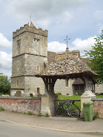
A beautiful day, clear(ish) skies, warm and dry, in fact, a perfect day for bagging the rest of the churches that are members of the Seven Towers Benefice:
Boddington,
Staverton,
Norton,
The Leigh,
Twigworth.
That just leaves Sandhurst and Down Hatherley so we will go that way and take a look today. Again, not a hilly day, couple of lumps but nothing drastic.
 Heading out of Hucclecote towards Churchdown again presents us with the closest to a climb as we go over the foot of Churchdown Hill, drop into the village and out onto Cheltenham Road East, toward Dowty and turn towards Down Hatherley taking us away from the hustle and bustle of the main roads and through some farming areas where we are warned of the possibility of cattle crossing. Soon, we are at the Down Hatherley Parish Church of St Mary and Corpus Christi, even my Latin stretches to that one.
 According to the BBC Songs of Praise book (no, I didn't know there was one either), this is among the 30 favourite churches. Dating back, at least in part to 11th Century, the perpendicular tower is 15th century although there was a Victorian major rebuild and renovation. The church has put on some special events to celebrate the 150th anniversary of the rebuild. The field opposite, shows a well, peering into which shows there is still water in it, built and dedicated to Revd John O'Brian, rector from 1985 - 2003. West of the church is the old school house, now converted to a house.
Leaving the church, we head on out towards Tewkesbury road, stopping briefly at Hatherly Manor hotel, reasonably famous in the locale as a hotel, wedding venue, conference centre and everything else a hotel should be. This is in fact, an old seventeenth century proper genuine manor house and some signs of this still exist. The garden is walled and there are the remains of a moat that would have some point surrounded the building.

We leave Down Hatherley and head to Tewkesbury Road, turning left towards Gloucester then right we turn in to Sandhurst. Proper village roads, proper village traffic. Again, the locals here don't seem to be familiar with other people coming the other way and there are one or two moments on some of the blind bends. Undeterred, I take a lap of the village and soon find myself at St Lawrence's Church. Nominally fourteenth century, the church was largely rebuilt in the mid 19th Century. The church originally came under the control of St Oswald's Priory in Gloucester and they would have provided the ministry. There is a board in the car park showing the results of a late twentieth century churchyard survey mapping out all the burials where this is possible. The churchyard does house some very impressive eighteenth century sarcophagi that I hope you can make out in the picture.
Another feature of Sandhurst has long gone. Up until the 1950s you could cross the river Severn by ferry between Sandhurst and Ashleworth on the other side of the river. From the panorama below, you can just make out Ashleworth Church spire towards the left. The road to the old ferry crossing is no more than a dirt track so I didn't take it to the river. I shall however, in the not too distant future take a trip to Ashleworth where there is a pub at the location of the old port, imaginatively called the Boat Inn.
Apologies for the slightly dodgy light on the right of the picture. Other things to note here are the Malvern Hills in the distance, centre of the picture and to the right, not so far away, I suspect is Barrow Hill with the little tuft of trees.
The journey home is a simple and fairly quick one, following Sandhurst Lane passing the excellent White Horse Chinese restaurant where Tina and I enjoyed a most excellent non-Valentines meal this year, leads us out near the site of the old cattle market near to St Oswald's. I take Estcourt Road, through Longlevens almost to the Golden Valley roundabout where I turn off through the housing estate to make a rare journey on a cycle path. This is acyually a very nice path that joins Liddington Drive in Longlevens to Barnwood right by Sainsbury's and C&G where my good lady wife is still hard at work. On to Hucclecote Road and I'm back where I started.
Total distance - 31Km
Average Speed - 29 KM/h
Weather - about 24C, Dry, Light southerly wind.


