Showing posts with label River. Show all posts

Friday, 18 June 2010

Elmore Back 16 June 2010

Today's ride was a little more than just Elmore Back but most of the rest of the loop we have seen before but the other way round. Not that I have cycled it backwards you understand, that would be foolish; I mean previously I took an anti-clockwise route, this time, clockwise. However, today, being a bright, sunny, warm day and I haven't been out for a couple of weeks, I thought it would be nice to have a relatively un-hilly bimble by the river and, surprisingly, didn't stop at any churches.  You can see the route here.


I left home and rode along Cole Avenue towards Quedgeley and crossed the canal at Rea bridge.  Turning left, the road is a gentle, near flat, well surfaced road.  If you look at the elevation, it is quite misleading and looks like a stonking great hill. The difference is actually only about 20 metres but this is as high as we go.  Riding conditions here are absolutely perfect, blue sky, warm but not scorching hot and just a hint of breeze so a reasonable pace is quite easy to keep.  This road leads to Longney and we pass the parish church of St Laurence.  Continuing on our clockwise route, the breeze is now gently blowing from the right.  4Km later and we meet the first turn off at a couple of houses known as Farley's End (honest) towards the river and the first dead end.  This road leads to Elmore Back.  The 'Back' isn't derived from 'Back of beyond' as you might expect but from ye olde English word 'Bec' meaning ferry.  It seems that for several hundred years there was a pub here called the Salmon Inn from which you could get a ferry across the river to Minsterworth.  It is the church at Minsterworth that you can see in this picture.  The ferry stopped in May 1941, I believe.  The route to the old ferry terminal (I presume) is now accessed along a stretch of footpath which I walked along but provides a bit of a pet hate of mine.  Apart from riding, I also enjoy walking and use these marked public footpaths and I am mildly irritated by the obstacles that farmers introduce.  In this case, there are a couple of stiles to cross (which I hoiked my bike over), the farmer whose land these footpaths runs alongside has run electric fencing and/or barbed wire around the perimiter fence and right up to the gates and stiles that provide public access.  Not preventing access but it would take just a wee slip and you'll be a bit uncomfortable.

The only way to go now is to retrace my path back to Farley's End and a left hander through Elmore before reaching my second and final dead end road leading out to the river.  Signed as Weir Green, this is little more than a farm track that again leads to the river which the Severn Way waymarked path follows.  Although there appears nothing of any great note here, it is a very pretty place and you could just sit by the river and soak up the sun.  A pub would go down well here so long as not too many people were allowed as it would ruin the peace.

Returning to the main road leads back to the road back over Rea bridge but I turn right back to where we started the loop in order to cross the canal at Sellars Bridge where the bridge is open to allow a narrow boat through.  From here, it is a quick run through Hardwicke and Quedgeley back home.


Total distance - 38 KM
Average Speed - 27 KM/h
Weather - about 23C, Dry and sunny, wind from NE, about 10 KM/h

Friday, 21 May 2010

Down Hatherley and Sandhurst 20th May 2010

Today's route can be found here.
A beautiful day, clear(ish) skies, warm and dry, in fact, a perfect day for bagging the rest of the churches that are members of the Seven Towers Benefice:
Boddington,
Staverton,
Norton,
The Leigh,
Twigworth.

That just leaves Sandhurst and Down Hatherley so we will go that way and take a look today.  Again, not a hilly day, couple of lumps but nothing drastic.

Heading out of Hucclecote towards Churchdown again presents us with the closest to a climb as we go over the foot of Churchdown Hill, drop into the village and out onto Cheltenham Road East, toward Dowty and turn towards Down Hatherley taking us away from the hustle and bustle of the main roads and through some farming areas where we are warned of the possibility of cattle crossing. Soon, we are at the Down Hatherley Parish Church of St Mary and Corpus Christi, even my Latin stretches to that one.

According to the BBC Songs of Praise book (no, I didn't know there was one either), this is among the 30 favourite churches.  Dating back, at least in part to 11th Century, the perpendicular tower is 15th century although there was a Victorian major rebuild and renovation.  The church has put on some special events to celebrate the 150th anniversary of the rebuild.  The field opposite, shows a well, peering into which shows there is still water in it, built and dedicated to Revd John O'Brian, rector from 1985 - 2003.  West of the church is the old school house, now converted to a house.


Leaving the church, we head on out towards Tewkesbury road, stopping briefly at Hatherly Manor hotel, reasonably famous in the locale as a hotel, wedding venue, conference centre and everything else a hotel should be.  This is in fact, an old seventeenth century proper genuine manor house and some signs of this still exist.  The garden is walled and there are the remains of a moat that would have some point surrounded the building.


We leave Down Hatherley and head to Tewkesbury Road, turning left towards Gloucester then right we turn in to Sandhurst.  Proper village roads, proper village traffic.  Again, the locals here don't seem to be familiar with other people coming the other way and there are one or two moments on some of the blind bends.  Undeterred, I take a lap of the village and soon find myself at St Lawrence's Church.  Nominally fourteenth century, the church was largely rebuilt in the mid 19th Century.  The church originally came under the control of St Oswald's Priory in Gloucester and they would have provided the ministry.  There is a board in the car park showing the results of a late twentieth century churchyard survey mapping out all the burials where this is possible.  The churchyard does house some very impressive eighteenth century sarcophagi that I hope you can make out in the picture.

Another feature of Sandhurst has long gone.  Up until the 1950s you could cross the river Severn by ferry between Sandhurst and Ashleworth on the other side of the river.  From the panorama below, you can just make out Ashleworth Church spire towards the left.  The road to the old ferry crossing is no more than a dirt track so I didn't take it to the river.  I shall however, in the not too distant future take a trip to Ashleworth where there is a pub at the location of the old port, imaginatively called the Boat Inn.

Apologies for the slightly dodgy light on the right of the picture.  Other things to note here are the Malvern Hills in  the distance, centre of the picture and to the right, not so far away, I suspect is Barrow Hill with the little tuft of trees.

The journey home is a simple and fairly quick one, following Sandhurst Lane passing the excellent White Horse Chinese restaurant where Tina and I enjoyed a most excellent non-Valentines meal this year, leads us out near the site of the old cattle market near to St Oswald's.  I take Estcourt Road, through Longlevens almost to the Golden Valley roundabout where I turn off through the housing estate to make a rare journey on a cycle path.  This is acyually a very nice path that joins Liddington Drive in Longlevens to Barnwood right by Sainsbury's and C&G where my good lady wife is still hard at work.  On to Hucclecote Road and I'm back where I started.


Total distance - 31Km


Average Speed - 29 KM/h
Weather - about 24C, Dry, Light southerly wind.

Thursday, 15 April 2010

Staverton, Boddington, Barrow 15th April 2010

The three villages that we are looking at today are all within a loop of about 6Km so most of the riding was to get to and from this loop through familiar territory and without stops.  Seeing as how the terrain is largely flattish, this gave me a chance to stretch the legs a little.  I also feel I must apologise for the quality of the photos.  I don't know if it was a bit of a funny light, crap camera or crap photographer but they do largely seem a little washed out.

The outward leg leaves Hucclecote riding towards Churchdown along Churchdown Lane.  Churchdown hill here is just about the only climb for the day and that's no more than about 4% for a couple of Km.  A quick downhill takes us through the East of the village, exiting onto Badgeworth Lane.  A left here and we are heading towards Staverton and our first stop at Gloucestershire Airport.  When I was a kid, this was called Staverton airport and used to host an annual air display which must have finished in the 1980s from memory.  We would sit on the grass banks between the road and the airport, far too tight to pay to go in, lean backwards and exclaim 'Whoooooaa' every time an aircraft went overhead.  The airport is used as a museum for aircraft back to the Second World War, some of which were (still are?) serviceable and would have been a part of the display.  The airport served as a training base in the war and the in air refuelling technique was developed here.  Now much of the activity are pleasure flights although there is a significant helicopter centre used by the emergency services.


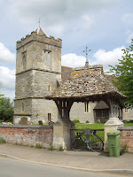
From the airport, crossing Cheltenham Road East into Old Gloucester Road leads us into the village of Staverton.  I'm guessing that for many centuries prior to the airport, Staverton was an inconspicuous farming village.  Based largely on the premise that it still is an inconspicuous farming village.  It is separated from the airport by about 1Km and isn't really on the road to anywhere.  Still, being me, I hunt out the local church.  And I have to say, the Parish Church of St. Catherine is one of the most unusual buildings I think I have seen. You have to hunt it down a bit.  It is in a lane that leads to nowhere but the church and you can't see the tower from the locale because the tower is barely higher than the roof of the main body of the church.  Indeed from a distance it looks sort of Lilliputian; a full grown chap could bump his head on that.   The church is 13th Century and is of cruciform shape although has quite obviously undergone some fairly serious modifications in successive years and even centuries.  Interestingly, in the porch, there is a list of the identified incumbents of the parish of Staverton with Boddington back to 1297.  The graveyard shows plenty of graves of just a couple of families and a couple of stones identifiable as early 17th century, although plenty I couldn't make out. The bottom picture here does seem to flatter the height of the tower.


Heading North out of Staverton, you soon come to Boddington, the parish of which incorporates Barrow where we shall go next.  It is also, curiously, home to an RAF base which, even more curiously, is rumoured to have underground links to nearby GCHQ.  The couple of kilometres between the two villages is dead straight between farmland on both sides.  I also noticed that it seemed to channel a fairly chilly Northerly wind.  At the end of the road, at a sort of unmarked junction, I am greeted by St. Mary Magdeline Church, naturally a member of the same Benefice as St. Catherine although a very different building.  Very few details to hand but it is 12th Century, which I reckon is just a bit older than its sister church in Staverton, although the tower, chancel and porch were rebuilt in the 14th century.  The entire church is of locally quarried stone.


This stone is set in the porch entrance.  I would love to think that the mark on it was from the original stonemason doing a 'this way up' but I strongly expect someone will shatter my illusions.


So, as promised to Barrow.  Fairly prominently, there is a large lump in the ground, I don't know for sure, but maybe this is the barrow from which the village gets it name.


Otherwise, the village is still largely agricultural although an ever increasing number of the buildings are being converted to dwelling properties.  That being said, it still has its fair share of quaint little thatched places.
Following a dead end dirt track (on purpose this time) there is a lake just off the road.  However, I am unable to get to it as it is across a footpath and it is a little rough so I will have to visit that walking some time.  However, at the end of the lane was my destination, a bridge to nowhere over the river Chelt which, at this place, seems much more attractive than it does in Cheltenham.

Back tracking along my dead end path, I rejoin the road and complete the Barrow loop back onto the road between Staverton and Boddington.  Back through Staverton and towards Cheltenham Road East where I turn right and, for the return journey, I pass through Churchdown along Parton Road and back onto Churchdown Hill before returning to Hucclecote.


Total distance - 26Km
Average Speed - 27 KM/h
Weather - about 12C, fine, bit overcast, North wind.